

Pavinakurve
The Government of Karnataka vide Notification No: PWD 107 PSP 2013 dated 09.12.2013, has declared the Port Limits of Pavinakaurve Port in Honnavar Taluk for the development of a Captive Port. In terms of traffic, this port will be highly dependent on its hinterland comprising of Uttar Kannada, Shivamogga, Belagavi, Haveri, Koppal, Bagalkote, Davangere & Bellary and parts of South Maharastra & bordering areas of Andhra Pradesh.
The vision is to develop the site as an All Weather, Deep Water, Multi Cargo, and Greenfield Port.
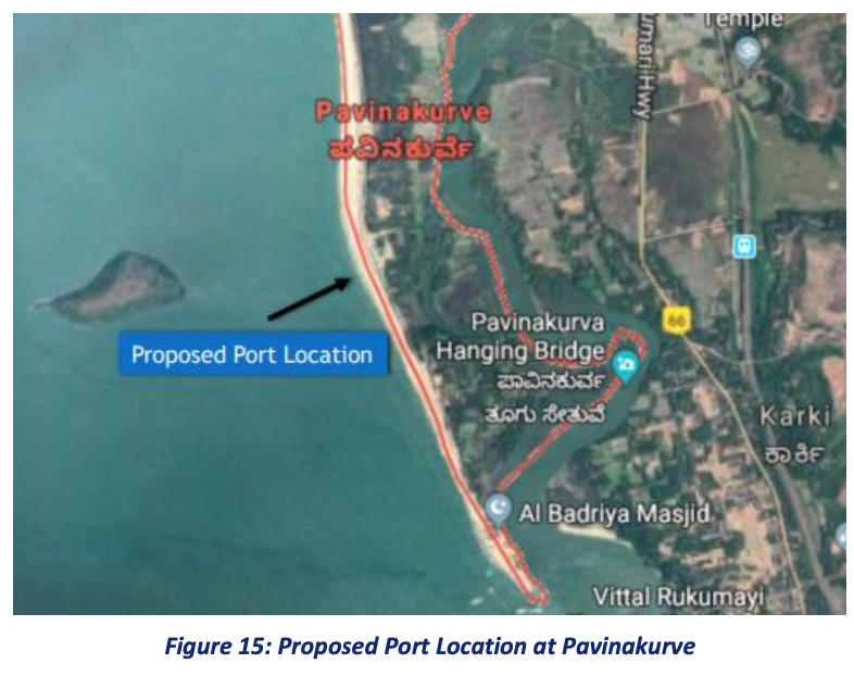
The proposed site for the development of Pavinakurve port is located near Pavinakurve village, Honnavar Taluka of Uttar Kannada district, Karnataka. The geographical location of the port is positioned at the following coordinates:
Latitude 14° 18’ 49.1” N
Longitude 74° 24’ 54.4” E
This location is approximately 5 km north of the Honnavar fishing port and is located along the coast of Pavinakurve village, situated on the right bank of the estuarine region of River Sharavathi and River Badagani.
The location of the proposed port is at the east of Basavarajdurga Island & sea shore of Pavinakurve village and the port’s reclamation shall leverage the available natural tranquillity, thereby reducing the requirement of break water and land reclamation.
Pavinakurve is well connected to the hinterland through National and State Highways, and has a lesser gradient compared to Goa & Mangalore, making it easier to move cargo by road. The National Highway No. 66 passes very close to the port site. With regards to railway connectivity, the Konkan Railway passes just a couple of kilometres away.
Thermal coal, Iron ore, coking coal and dolomite would be the key commodities that can be catered by the proposed port. It shall operate as a Commercial Port for the Industrial hinterland of Central & North Karnataka and the adjacent state of Telangana, and the Southern part of Maharashtra.
It is estimated that the proposed port has a potential of attracting thermal coal traffic of 3 MTPA, which can go up to 4.2 MTPA by 2030. The current potential is estimated based on Pakinakurve’s location which is better placed given the shorter distance from most of the Steel plants and power plants located in the hinterland.
The port is also strategically located to handle iron ore moving inbound to Bellary region as compared to Krishnapatnam since the distance from Pavinakurve to Bellary is significantly lesser than the distance between Bellary and Krishnapatnam port. This will result in reduced logistic costs and Pavinakurve port may become the primary port to handle iron-ore traffic in future.
The traffic cargo potential of the proposed Port is expected to be 14 MMTPA in the short term and will potentially increase to 37 MMTPA in the long term by FY50. A Detailed Project Report (DPR) has already been prepared to envisage the port under the PPP model.
The following infrastructural facilities are envisaged for the Proposed Port :
- Pavinakurve port is envisaged as a modern Greenfield Deep water Port to boost EXIM – with capacity of 14 MTPA and having 2 berths in the initial phase.
- The Port would have modern environment friendly high throughput equipment with deep draft berthing facilities for handling of cape size vessels up to 1,80,000 DWT capacity, enabling the Port to meet the present and future requirements of trade and shipping.
- Construction of breakwater protected harbour on the leeward side of the Basavarajdurga Island estimated with 8 km long channel
- The average productivity is envisaged to be 70,000 TPD for iron ore and 40,000 TPD for coal
- Being predominantly a bulk import terminal, it can serve the social good through export of agro-products and the locally finished steel products and can also supply fuel to the existing power plants in the hinterland.
Port Details | Description |
Port Capacity | ~14 MTPA |
No. of Berths (min) | 2 |
Vessel Draft | 18 sq.m |
Total Land Requirement | 114.9 Hectares (284 Acres) |
Land for Approach Road & Rail Connectivity, utilities etc. (to be acquired) | 25.9 Hectares (64 Acres) |
Berth Length | 600 sq.m |
Turning Circle | 600 sq.m |
Channel length | |
Approach Channel | 8900 sq.m |
Entrance Channel | 1100 sq.m |
Channel Width | 240 sq.m |