

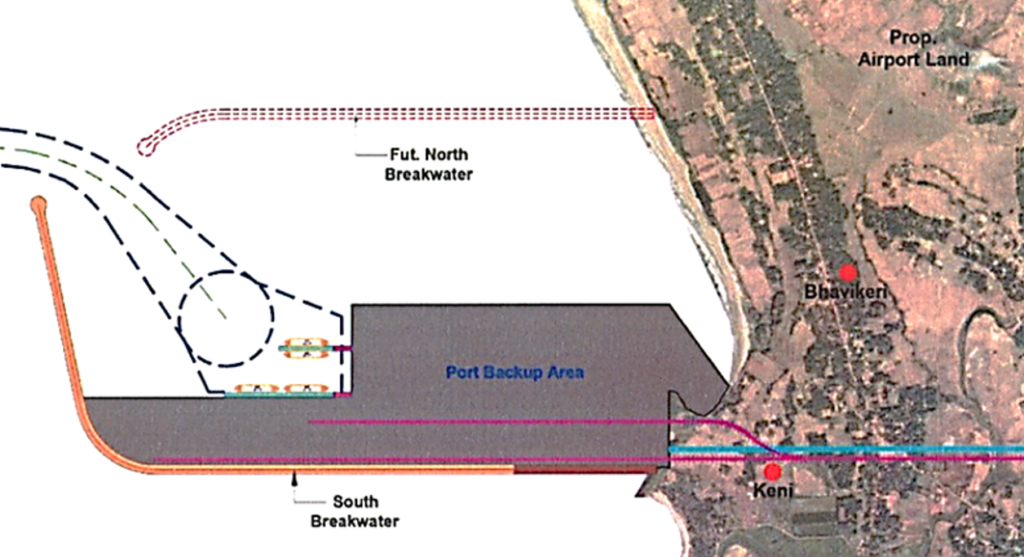
Keni Port
Considering the rising demand in comparison to the current meagre cumulative capacity in the coastline, there is a clear need for an additional deep draft port, specifically to be located in the northern end of the coast, considering the presence of NMPT in the southern end. Keni is one such suitable site for an all-weather, greenfield, multi-cargo, direct berthing, deep-water and commercial port.
A bifurcation of the port limits for the proposed Keni Port was undertaken while keeping the overall limits for the proposed Keni Port was undertaken while keeping the overall limits of the Belekeri Port Intact. The Gazette Notification no. IDD 280 PSP 2021(E-632148) was issued on 11.04.2022.
The Government of Karnataka has accorded the Administrative approval vide G.O. No. IDD/68/ PSP/ 2022 (E-746686), dated 08.04.2022.
Keni port is envisaged as an all-weather, greenfield, multi-cargo, direct berthing, deep- water and commercial port for handling cargos on the west coast in North Karnataka region to serve the industries in the hinterland area covering Bellary, Vijayanagara, Hubballi, Kalaburagi and South Maharashtra.
The proposed site is located at a distance of 144 km from the Hubli airport, 8.2 km from the Ankola Railway Station, and is approximately 5 km away from NH – 66, which runs along the western coastline of India, connecting Mumbai in the north and Kanyakumari in the south.
The location of the port is well connected to the hinterland through National and State Highways. Through existing roads, the proposed Port location is approximately 4.2 Km from the Edapally-Panvel or Kochi-Panvel Highway (NH 66). With regard to railway connectivity, the Konkan railway line is located at a horizontal distance of 3.8 km from the site.
There is a hinterland potential primarily of coal and coke cargo, which is being utilized for steel, cement and power plants. It is further supported by Iron ore, limestone, dolomite handlings and the export of finished steel products.
The port is expected to have a capacity of 27 MTPA in the medium term and 56.5 MTPA in the long term.
Port Details | Description |
Port Capacity | ~30 MTPA |
Port Vessels | Capsize, Handymax & Panamax |
No. of Berths (min) | 2 |
Vessel Draft | 18 sq.m |
Total Land Requirement | 200 Hectares (494 Acres) |
The following infrastructural facilities are envisaged for the Proposed Port :
- Provision of two breakwaters,
- The port shall be adequately dredged to handle vessels upto 2,00,000 DWT.
- The marine infrastructure for the facility would include the required berths, turning circle, channel of required length etc.
- Provision of tugs, mooring launches, survey launch and pilot launch.
- Backup area of approx. 500 acres is proposed to be created with dredged material.
- No land acquisition or displacement is envisaged for the port except for the road and rail connectivity.
- Appropriate width of roads up to backup area for commodity / trucks movement.
- Provisions for utility infrastructure such as pow- er and water would be developed as per the requirement.