

Karwar Port
Karwar Port is located at the northern extremity of the state on Latitude 14° 48’ N and Longitude 74° 7’E. The Karwar port division is one of the 4 divisions of the department consisting of Karwar, Sadashivgad, Belekeri, and Divisional headquarters of Karwar.
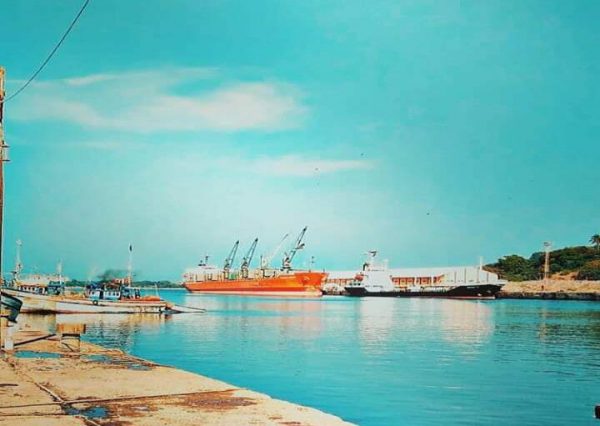
The Karwar Port is an I.S.P.S compliant all-weather port in Karnataka. The Karwar Port is acclaimed as one of the best natural all-weather ports on the West Coast. Given that there is only one major port at Mormugao between the major ports at Mumbai and Mangalore, Karwar, which is located midway between the ports at Mumbai and Mangalore, caters to the trading needs of northern Karnataka, Andhra Pradesh and Maharashtra. The port is located beside the National Highway (NH66) that connects Mumbai and Kochi, one of the country’s busiest corridors. Also, it is only ~8 km away from the Konkan Railway network.
Karwar caters to the requirements of ~2 lakh sq. km of Hinterland of Northern / Central Karnataka, comprising the districts of Belgaum, Dharwad, Gadag, Bijpur, Bagalkot, Raichur, Bellary, Hospet, Chitradurga, Shimoga, and a few districts of South Maharashtra, West Andra Pradesh and Southern Goa.
Given the strategic location of the Karwar Port, it has a lot of untapped potential and is currently underutilised. To unlock the port’s potential, the Government of Karnataka has undertaken the 2nd Stage development of the port under Sagarmala Scheme of MoPSW with state-share. The components include the extension of a 1,508-meter jetty, construction of new breakwaters of 1,300 meters in length, increasing the port basin depth to -14 meters and other infrastructure at an estimated cost of Rs.1,200 crores.
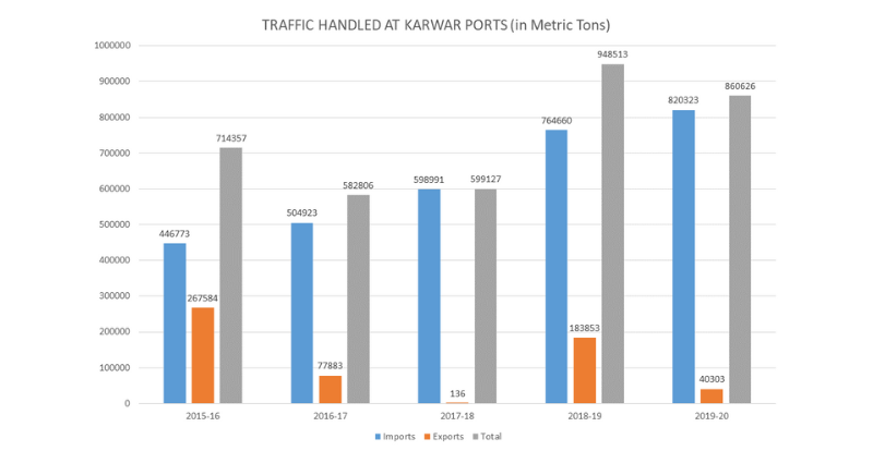
Non-Major ports in Karnataka have seen continuous growth in traffic, especially through export-import (Exim) operations over the past 4 years. A majority of these transactions have been carried out through Karwar Port. The principal commodities operated through Karwar Port are provided as follows:
Exports | Imports |
|
|
Karwar Port has been declared as a container freight station. The basic infrastructure for container-handling is under construction. Private entrepreneurs have already constructed 35 Liquid Cargo Storage Tank Terminals with a storage capacity of 1.5 Lakhs cubic metres. The port is permitted to handle class “C” & “B” petroleum products.
VESSEL NATIONALITIES HARBORING AT THE NON-MAJOR PORTS IN KARNATAKA
Europe | UK, Cyprus, Greece, Turkey, Norway, Croatia, Malta |
Americas | Honduras, Panama, Bahamas, Saint Vincent, Cayman Islands |
Africa | Liberia |
Middle East | UAE, Qatar, Iran, Saudi Arabia |
Asia | Indonesia, Cambodia, Thailand, Singapore, China, Malaysia, Sri Lanka, Russia, |
Existing Infrastructural Facilities at Karwar Port:
The key infrastructural components that are available at Karwar Port and were developed under 1st Stage are as follows:
- 515 meters Wharf accommodating two ships with other matching facilities.
- 205 meters lighterage wharf of 3.5 Meters
- 250 meters. long breakwater.
- Departmental transit sheds – 4 Nos.
- 30 Tonnes capacity Mechanical weigh bridge.
- Bunkering facilities by IOC.
- Diesel Generator 63 KVA.
- Land Area available approximately 200 acres.
- Sufficient cargo handling equipment like Gantry crane, escort crane, pay loader, shovels, JCB, forklifts etc., are available with private entrepreneurs.
- 45 liquid cargo storage Tank Terminals of 2 lakhs cubic meter installed storing capacity were constructed by private entrepreneurs.
- Signal Station, Flag – mast and transit marks Tidal observatory watch tower as per ISPS
- Traffic control Tower and communication tower with Automatic identification of Ship (AIS) with Rader and digital – VHF
- Oil Spill Response Equipment IMO Level -1
- Tugs for berthing and un-berthing operations charted by private parties.